Flora itinerary: Shady Oakwood - Albarca
Information
Level
Low
Distance
2.20 km
Drop
100 m
Duration
1 h
A route over the flat areas and slopes of the shady side of the shoulder on which the village is perched.
The soil is deep here thanks to erosion and sedimentation of the red sandstone of Albarca and lutitic materials with gypsum. The heads of the stream beds that start here reveal outcrops of limestone.
Flora route
Height difference: 100 m; starts at 780, goes down to 720 and climbs to 820 m.
Starting point: Entrance to the village of Albarca. Boundary cross at the start of the road leading up from the C-242 to the village. Return to the same place.
Time to allow: ¾ hour walking; stopping time must be added to this.
Length of the route: 2 km.
Recommendations: the route can be followed at any time of year, but especially in autumn, to appreciate the colours of the deciduous trees; times of day when the sun is high in summer are not recommended. Footwear suitable for walking on paths should be worn.
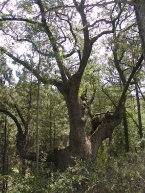
Route: Just opposite the boundary cross, on the other side of the road, a farm track goes off to the right; follow this until it ends. On the right you can see the flat area of La Colomina, still under cultivation. Ignore turnoffs to the left, leading to fields planted with fruit trees, and soon after you pass the old Corral de l’Agustí, now in ruins. Carry on along the track and soon you come to some former fields, now abandoned |1|. Among these fields is the Parada de la Guineu with its mediaeval rock-cut graves. When the track comes to an end, take a path going up to the right |2| into the trees. When you get into the woods, turn left to descend to the bed of the small watercourse of La Rasa |3|. Here you can see the distinctive Cappare oak ahead of you. After crossing the watercourse on a footbridge made of tree trunks, go up to the right to the top, where you can take a look at the above-mentioned tree. To leave the flat ground, |4| carry on going slightly uphill on a narrow path that leads among different species of pine trees to a place where charcoal burners used to work. From here, go up to the right and then sharp left to find the path, stone-paved in places, that crosses the stream bed again |5| and then leads to its head. From there, go up to the left through an area without trees as far as the flat ground of the Collet Roig and the ruins of the old wayside inns known as Els Hostalets. Take the track to the left to the village square and then go back down to the boundary cross.
Image gallery